The Berkswell Society

Two walks on The Grand Union Canal footpath

The Grand Union canal was the M1 of the late 18th and early 19th century.

Formed from several canals it linked Birmingham to London.

Widened during the great depression at public expense in the 1930’s both to improve its economics and provide employment it fell out of commercial use soon after the 2nd world war.

These two walks are very simple and start at the Hatton Locks car park. (Cost £1.30 per day).

Great bacon butties.


There is a great coffee shop about 200 metres from the car park. Cross the bridge and walk up to it. The coffee shop is open for takeaway food and (non-alcoholic) drinks during lockdown.

How to find the car park


Drive towards Warwick down the A4177. As you enter Hatton (just past the signs to Hatton World) there is a very big pub on the right-hand side called the Hatton Arms. Driving down the hill from there for about 200 metres you will see a small road to the right,

There is a “fingerpost” sign on the left side of the road pointing to the right saying “Hatton Locks” with a canal boat picture.
Put “Canal Road Hatton” in Google and it will take you there.

There is plenty of Canal and River Trust seating in the area where you can sit, socially distanced, and eat your lunch/elevenses etc. Legally, you should not sit on the seats on the gravel area near the café during lock down.

Walk to Warwick

(2 miles to the bottom lock and 3 miles to Warwick centre)

The car park it close to the top of a flight of 21 locks which bring the canal up from Warwick to Hatton.

The lock flight is unofficially called “the Stairway to heaven” after the Led Zeppelin song.

https://www.ourwarwickshire.org.uk/content/article/hatton-locks-stairway-heaven

Canal towpaths are narrow in places. If you meet someone it is best you minimise contact during lockdown. It is polite to greet someone as you draw close and then face the canal or hedge to let them pass, thereby minimising and already small chance of virus transfer

If you go south from the car park you walk down the lock flight. The tower of the church in Warwick beckons. Good underfoot, a walk that can be done in trainers. It is up hill on the way back but hardly steep – this is a canal.
hatton-locks-up
Click image to enlarge

Walk to Shrewley village and Shrewley tunnel

(5 miles)

Again starting from the coffee shop turn northwards from the car park, crossing the bridge and going past the café towards the top of Hatton locks. this will take you to Shrewley.  From there the canal then runs level all the way to Knowle (8miles).  Shrewley a distance of about 2.5 miles.

After a short distance you will come to John's bridge (55). If you leave the canal footpath onto Dark Lane Hatton Country World is just a short detour up the hill.

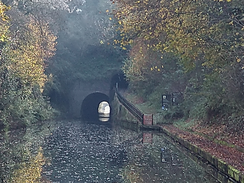
As you come towards Shrewley, you will see the canal tunnel goes underneath the village.

Walkers follow a track up into the village to the road. Just to your left you will find a well-stocked village shop where you can buy the things for lunch or further down the high street is the Durham Ox pub and restaurant.

If you cross over the road another track takes you through a pedestrian tunnel back to the canal which is worth the experience.

This section of the canal is absolutely flat. Generally good underfoot, there are a few sections that get muddy in winter when boots would be a good idea.
Click image to enlarge

Copyright © Berkswell Society. All right reserved.